Welcome to Tuscoro.com

Read More......


>

Sunday, June 19, 2022

Cataclysmic Pole Shifts of the Past PART TWO


And the Geological and Archeological Evidences

The Big Horn Medicine Wheel 

High in the mountains of Northern Wyoming situated at one of the highest points of the mountain is an odd arrangement of stone of which one can’t help but think of Stonehenge while looking at it despite having no real similarities in appearance.


Fig. 1


I had debated on whether or not to write about this curious feature at first, but it showed strong promise as having BC origins, and this intrigued me, I had no idea as to how much promise it held. 

First let me say that I do not believe that it is a Medicine Wheel as perceived in the usual modern day traditional ideas and uses of the many that have hypothesized and supposedly used it for their own purposes, even over the last few hundred years. It is said to have been constructed by plains Indians around 300-800 years ago. Why such a broad spectrum? Who was there to see them build it? Was it documented by some unknown source in some unknown place? How many have laid claim to its construction? None have claimed it as of yet, if they had built it, how many could explain why it was built and what its purpose was? Have they lost this knowledge? If so, how would they know that it was their ancestors who built it? The Crow who arrived in the area about 1400 AD said it was there when they got there. 

The Big Horn Wheel was first brought to my attention by a friend who sent it to me for BC origin analysis as he new the subject of my research. Upon first looking at Jack Eddy’s diagram I could see it most likely had BC origins.

The article that I read had some comments that just needed questioning, and the reader needs to know the facts pertaining to this from another perspective. For the reader’s convenience, I will include a small portion of the article. 

Astronomical Alignments:

In 1974, an archaeoastronomer named Jack Eddy visited this Medicine Wheel and studied its alignments, that is, its arrangements of rocks, cairns, and spokes. He found the arrangements point to the rising and setting places of the Sun at summer solstice, as well as the rising places of Aldebaran in Taurus, Rigel in Orion, and Sirius in Canis Major -- all bright, important stars associated with the Solstice. Later another astronomer, Jack Robinson, found a cairn pair that marked the bright star Fomalhaut's rising point with the Sun 28 days before solstice.
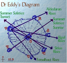


Fig. 2

Sighting from cairn E through the center hub (which may have supported a pole) marks the summer solstice sunrise. Sighting from C through the center marked the equivalent solstice sunset.

Standing at cairn F, one could sight the once-yearly dawn, or heliacal, risings of the key stars Aldebaran, Rigel, and Sirius, which play symbolic roles in an ancient Cheyenne Massaum ceremony and are also important stars in the sacred Lakota circle constellation "The Animal".

The dawn or heliacal rising of a star is important because it pinpoints a date exactly. This is the day a star is first seen, just before dawn, after it has been behind the Sun for an entire season. From about 1200 AD to 1700 AD, these 4 stars would have acted as solstice markers for the Native Americans - Fomalhaut (F to D) would rise 28 days before the Summer Solstice, Aldebaran (F to A) would rise during the 2 days just before the solstice, Rigel (F to B) would rise 28 days after the solstice, and Sirius (F to C) 28 days after that, at the end of August  

Now although there are many other things I could point out in this article, I will only address the bold text points with a little deviation. I don’t know who wrote this article but it is typical of the things that seem to be among the accepted explanations. 

We read about the alignments of Aldebaran in Taurus, Rigel in Orion, and Sirius, and my first question is, who cares? For us to believe that these alignments were somehow significant to pinpointing some date with constellations is ridiculous. What? You can’t do that with the alignment of the sun? Does the Sun rise in a new location every day? Would this be like trying to find the forest but can’t see it for all the trees? Why would the ancients ignore the sun’s rising positions and choose a FIRST APPEARANCE of a star instead. You don’t need some big wheel made out of stone to SEE its FIRST APEARENCE. Isn’t a FIRST APPEARENCE sufficient to pin point that day in which it FIRST APEARED? And do we need to hike to the altitude of 9600 feet to SEE its FIRST APPEARENCE? Is any one catching what I’m saying? Are we insinuating that the ancients were idiots? Isn’t it obvious as to who the idiots are? Let me say at this time, I do not believe that the Indians as we know them today are the ones who have constructed this wheel, and that this comment is not for the purpose of diminishing this noble people. With the exception of a few tribes such as the Lenape and Ojibwa, the various tribes had no writing system and chose to resort to oral tradition. Since none of them claim to have made the marks upon the rocks or to have been responsible for the Earthworks of the Mississippi Valley or Utah Earthworks, why would they then build this wheel? You will notice I refer to the builders as the ancients and not the Indians.

In this same article it is said that these stars which play symbolic roles in an ancient Cheyenne Massaum ceremony and are also important stars in the sacred Lakota circle constellation The Animal. Yet in the links provided in the article (if one should visit them) you would find nothing pertaining to these stars which are the focal points to their theory. 

In the article, it is written: From about 1200 AD to 1700 AD, these 4 stars would have acted as solstice markers for the Native Americans. Why? Was the Sun missing in those days? But the one statement that got me more than anything else was the concluding statement, and hence marking the end of summer and time to leave the mountain. This is the most asinine statement yet. I don’t suppose the increasing cold weather and the turning of the leaves or even the early snow might have been a clue as to when to leave the mountain? What? They sat up there day after day waiting for this prophetic sign? Who was tending the sheep down below? 

A friend has mentioned that this could simply be a game of duck duck goose, and is it any less ridiculous than the theory for the alignments with stars? 

What is it?

In order for anything pertaining to this geo-glyph and/or observatory to make sense, we need to understand some things pertaining to the ancients of which the Indians are in part the descendants of. What was it that they worshipped, Stars? Many of the tribes in the origin and creation legends make note of a supreme being and many of those acknowledge the Son of God (including the Aztecs). Many of the tribes, though they communicated in many ways, made it clear that they worshipped the Sun, or more definitively, that which was behind it. Being clarified, they meant the power behind it. The only logical explanation in which this circle of stones was built in such a high place is not for a game of alpine duck duck goose but because of the vantage point of being able to see the largest spectrum of the horizon. 

In the Native American Petroglyphs, the symbol for sky or the horizon around it is the circle with a base meaning of Holding, in other words it is my belief that the circle itself represents the horizon as viewed from this ideal location. (See the Article; Aztec Navigation Glyphs) Each of the cairns is positioned to represent a specific location upon the horizon, its equivalent in the symbol based petroglyphs being that of a dot or something similar. Although some of the cairns appear to be built in the shape of a U, I would think that they were intended to be a circle which here again is implied by the symbol Holding. Regardless, I would have no doubt that they are positioned for viewing some point such as a sunset or sunrise to mark a point in time or possibly a place in the distance such as a city.. 

The purpose of marking some point in time would be best understood by us in our celebration of the Birth of Christ on the specific day of December 25th (which of course is not the correct day). We also have specific means by recording and observing the shortest day, the longest day and the two times each year which mark a time when the day is equal in time with the night or the mid point between summer and winter. We don’t need stars for this but there are many reasons why anyone (including the ancients) wanted to know these times specifically. 

Also, take into consideration that regardless of the mountains around a valley, the same thing could have been accomplished in a valley, why did they choose to construct this wheel at the highest point? Many times throughout scriptural history we read of Prophets going to the tops of mountains to speak with God. Even today, many feel more connected when praying in the mountains. The point is that it would seem quite clear: the reasons for its construction are religious in nature as I can find no other reasonable explanation which warrants its construction at one of highest points around. 

There are two things that need to be determined. (1) When was this built? I don’t think it is possible to find out exactly when it was built but perhaps it is possible to discover if it had Origins in BC times. (2) We have the need to discover if it truly has any Solstice/Equinox alignments or related perspectives as well as comparing AD times with BC Times.


 Fig. 3


In looking at Eddy’s drawing of the wheel above, we see the alignments that he noticed. It would seem that he noticed two solar alignments, of which, both appear to be noteworthy.


Fig. 4


It has been said that Eddy’s alignments would have been more accurate for 1200 to 1700 AD. I would love to hear what this excuse for non accuracy is based upon; let’s see how accurate it is in the above image (Fig. 4). The red lines are based upon full sun above the horizon at 5.3 degrees elevation which is the first point of Full Sun. At Eddy’s sunrise position, I must admit that the sun peeks over and casts its first light at his projected point with half sun exposed in between his projection and the red line. This is with a visual horizon at 100 feet higher at 4.3 miles away. What this means is that Eddy’s proposal of alignment is acceptable for the Summer Solstice sunrise. The red line at the sunset position is basically the same in reverse; for sunset at the red line we have full sun at 5.3 degrees elevation with a visible horizon at 1600 feet lower at over 30 miles away. If this is the case and not much adjustment is needed, this would place his sunset position nearly correct at full sun. I find, at two other points, satisfactory alignments with Winter Sunrise and Sunset, but not as acceptable as the summer positions, however, who is going to be up there in 4 to 6 feet of snow to see it? I cannot find any other solar alignment within this stone circle based on today’s North.

What if this were constructed in BC times? What solar alignments would we find?

According to my compiled research, I have established a BC North Pole and with this pole in mind let’s see what we can come up with. 

In the following image, Fig. 5 using Eddy’s cairn letters, you can see a red line extending from Eddy’s C Cairn to F which would represent BC north (F) and south (C), Notice the line does not intersect with the center. I would almost think this was intentional as if to say, it was not meant to align with the horizon. In similar stone geo-glyphs with solar alignments, I have noticed that there is a North reference. I would suspect that if the outer circle correlates with the meaning of horizon then is it possible that the center cairn represents the Sun being held and that the outer dots are showing different locations on the horizon?

The Yellow line extending from D through the middle points to the BC Summer Solstice Sunrise. This position is calculated at 47 degrees azimuth and 4 degrees elevation of the sun (5.3 degrees being FULL Sunrise with a 0 degree horizon). The actual visible horizon is located some 15 miles away and is 1600 feet lower than the wheel, which means at 4 degrees you would have full sunrise. At cairn D, we have a perfect alignment.


Fig. 5


At the sun’s position with the line at cairn B extending through the center based on 324 degrees azimuth at a 0 degree elevation, if the visible horizon were not 70 miles away and 1000 feet lower we would have a ½ sunrise, but it is 1000 feet lower and 70 miles away, so this means that at approximately 324 degrees azimuth we have full sun, another perfect alignment. Keep in mind that at 60 degrees Latitude, the sun moves laterally more than it does vertically. 60 degrees was the latitude in BC times, today it is located at a Latitude of 44.83 N.


What about an equinox sunset or sunrise for that matter? In Fig. 6, from the position of cairn A, a line extending though the center in BC times would be about 260 degrees. The visible horizon is some 150 miles away and 3000 feet higher. Not taking this into consideration and based on an equal elevation; full sun (at a 5.3 degree elevation) would be at 162 degrees. However, considering the horizon is 3000 feet higher and 150 miles away, if an additional 1 degree was added in elevation (which seems reasonable), full sun prior to sunset based on this information would be at 260 degrees azimuth, which is a perfect alignment for the equinox sunset. However, this is one that I would have to see for myself.


Fig. 6


The equinox sunrise, in order to fit into the same alignment opposite of the line in the previous picture would require 79 degrees, but the sun at this point would have just have peeked over the visible horizon which is a little over 7 miles away and 300 feet lower. Although this could prove to be an accurate alignment, I’m just not satisfied with it.

At full sun, the alignment would look something like this.


Fig. 7


I would think that the equinox sunrise would be considered an important alignment and one that the ancients would be most concerned with, however I must say that although it is good enough, I was slightly disappointed. I guess I’ll just have to go see for myself that is unless there is another possibility. How about this…? SEE Fig. 8


Fig. 8


The only thing that puzzles me about this is, why not set up a cairn in such a way that if a line were drawn on it, it would pass through the center? I don’t know why this is important to me, it just is. Perhaps I am being too meticulous. Now the fall and the spring equinox sunrises occur at 98 degrees azimuth, both alignments in the above picture are at 98 degrees. Is this just a coincidence? If so, it’s a pretty good one.


Winter Solstice


Now although I really don’t think anyone would be there to witness it, and can’t think for the life of me why anyone would indicate a winter solstice sunrise at such an elevation, it would appear that it is present, See Fig 9. Considering that the visible horizon is about 300 feet lower and a quarter mile short of 7 miles away at 141 degrees, if a line were drawn from the center cairn through cairn B (Opposite Summer Sunset); this would mark the exact placement of 141 degrees azimuth at near full sun.


Strangely enough, if we allowed the sun to continue to a full sunrise, we would be at approximately 159 degrees. Keep in mind that the sun at this point during the winter is traversing the sky in more of a horizontal path than a vertical one. If a line were drawn from Eddy’s cairn D to cairn E and beyond this also would point directly at full winter solstice sunrise.


Fig. 9


With the winter solstice sunset, we have remarkably the opposite. A line drawn from the center through D which is at 224 degrees azimuth is exactly the opposite of the summer solstice sunrise with the visible horizon only a mile away at the same elevation. At 224 degrees the sun has gone down with only about 1/4 of it exposed. If we come back to full sun prior to solstice sunset, the sun is at 195 degrees azimuth. With careful positioning of our lines, we can get two alignments that meet at a measurement of 195 degrees. What I mean by careful is for you to notice where the line leaves cairn F and passes through D and where it leaves cairn A and passes through B, it is not perfect. Maybe I’m just being too meticulous again.


                             Fig. 10                                                          Fig. 11


What about other alignments? In looking at cairn E naturally I wanted to see if this aligns with something significant.  Why is it removed from the outer circle as if to imply that it has some other meaning? 

In Fig. 12, If a line were drawn from the center of the medicine wheel to cairn E it marks a place on the horizon some 77 miles away and 100 feet higher than that of the wheel. The dates we have a sunset with full sun at this location in BC times would have been the Evening of May 11th and the evening of July 30th which is at 297 degrees azimuth. What is interesting about this is that from the sunset of the 11th of May to the Summer Solstice sunset is 40 days, the 11th of May and the 21st of June (not inclusive). The return trip of the sun from the 21st to the 30th of July (inclusive) is also 40 days. This same thing appears in other suspect Adena mound sites, why would these suspect Hebrews be observing a 40 day period let alone two consecutive? Why this 40 day observation period? 

It would appear to be an 80 day period of two 40 day observation periods. What could have been the purpose of this 80 day observation? In the scriptures we observe the 40 day fast of Moses to receive the higher law then after receiving it, Moses returned to the Israelites whereby he had seen their iniquities and broke the tablets. Then he returned to the mount and fasted another 40 days to receive the lesser law. Interestingly enough, the Aztecs had a similar fasting ritual. The point is that according to today’s North, it would not have any meaning whatsoever and the scientists would be just as confused as they seem to be concerning the Murray Farm Tunnel.


Fig. 12


What about the sunrise direction? Is it also present there? Well guess what. Yes, it is and without a stretch of the imagination or the facts, a line drawn from cairn D through the center is Summer Solstice Sunrise. In Fig. 13 a line drawn from cairn D through cairn A will give us a 62 degree azimuth for the Mornings of May 11th and July 30th. It is a repeat of the previous two forty day periods except that it is for sunrise instead of sunset.


Fig. 13 

But wait a minute, haven’t we heard this before? It would seem that the same dates are two consecutive 40 day periods, which are also present at the Milford Earthworks.

The Plains Indians didn’t build the Milford Earthworks. Some people called the Allegwi did. You know, those people who were run off and went south and became the Aztecs? 

Yes, the Aztecs who in part came from the North who also have two consecutive 40 day periods of Fasting, like Moses when he received the first tablets for the Israelites and after breaking them had to return to the mountain and fast another 40 days? Where did the Allegwi learn this? Oh well, no matter. I’m sure it is all a coincidence. 

All of the above information is exact and true to the best of my knowledge without any stretching of the truth or the imagination. Visual horizons were considered in each case and determined accordingly. Anyone who would like to see the full details of how I arrived at each location is more than welcome and I will be happy to explain it further. But the best way to verify all of this is to go to the site and set up wooden stakes at the adjusted locations according to BC North, we could implement a pole change back to where it was, but history shows this can be catastrophic and besides, it won’t be long before it will be happening again. I hope you are all prepared.


The Geo-glyph 

Many will not understand what is said in the following but it will reach those for whom it is intended, even so, I will do the best I can to make it clear. There is much speculation as to what a medicine wheel is and what it was used for. Aside from you creating a medicine wheel for your purposes, I have yet to see anyone identify what they were used for, the idea or concept in some cases is similar, but not even the Indians who use them today seem to understand what they were. This is because the knowledge of the symbol based glyph system is nearly extinct. 

These circles of stones were created by the same people who pecked the glyphs on the rocks found everywhere in North America, or their descendants who retained the knowledge of the hieroglyphs. Of the many types of Medicine Wheels as we have come to know them, each reveals its intended purpose by the way it is laid out and where it is located. This method of laying out the stones on the ground is based upon the exact same principles as the Native American petroglyphs themselves. For example, the following Medicine Wheel, Fig. 14, was used for communicating with their God and including their ancestors.


Fig. 14


If you view this as a glyph and recognize the various symbols that make it up along with the positioning of the symbols, it will identify its purpose. The symbols that you see within this wheel use the base meaning of Holding, Place of Dead, and Holding in one place. The individual would sit in the center with the idea of being surrounded by his ancestors who have passed on, by the ancestors surrounding them no evil could come to them and their purpose for coming to the medicine wheel is thereby uninhibited by evil spirits.

In Fig. 15 the medicine wheel was used specifically for communicating with the creator, God above, the Son of God, or the Sun of God. I am the light and the life of the world.

This is said 11 times in our scriptures and yet we suppose that the Ancients didn’t understand this? Most of us don’t understand it, but the Ancients did. It will ALWAYS be located where it catches First Sunlight. If it isn’t, then it was built by someone other than the Ancients; such as the new-agers, or a later people who have forgotten its purpose or never knew it.


Fig. 15

Simple, direct and to the point. 

There are many other uses of medicine wheels and each identifies its purpose by its construction. With the knowledge of the symbol based glyph system of hieroglyphs, we can identify its purpose. Fig. 16 is just another of the many that exist.
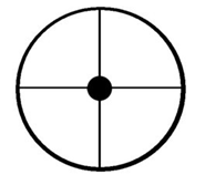


Fig. 16


The Big Horn Medicine Wheel had a similar purpose to that of Fig. 15 and 16; however, it has many interesting things integrated into it. In addition to the alignments which seem to correspond with different aspects of the Sun, hidden within the wheel is still more that clarifies its purpose. If one is to connect the dots so to speak it reveals the following in Fig. 17.


Fig. 17


With a little understanding of the glyphs, the circle itself (as pointed out earlier) represents the Horizon as being the border of the sky. The center Cairn represents the Sun, Son, or creator who oversees all that is under the sky and in the sky. Each Cairn positioned at the many places around the circle represents a specific location on the horizon or a point in time which was significant and important to the Ancients as it relates to that which they believed. 

When we join the perimeter Cairns it reveals a well know symbol which is quite fitting in what it represents. I’m not talking about the meaning attributed in general to the Star of David, but rather speaking of Him who is of the lineage of David who is the bright and morning star, a concept which is very applicable. 

Turning to the pages of…


Temples Of the Most High (Significance of Ancient, Geometric Symbols) pg.240,241

“We will now draw these symbols that you may better understand them:


“You will notice that there are two triangles, one with the point downward, and the other with the point upward. These are combined in the symbol of the interlaced triangles, or the six pointed star. The triangles when used separately gives each triangle a distinct and separate meaning. The one with the point upward, is called the symbol of manifestation on the, material plane, and symbolizes mankind focusing their thoughts on God; the triangle with the point downward represents manifestation on the spiritual, or Divine plane, and symbolizes God’s consciousness focalized on mankind. In this six pointed star formed by the interlaced triangle we symbolize the blending, or uniting, of the physical and the spiritual.


        The square represents building uprightly on a strong secure foundation. The circle, which is endless, is the universal symbol of eternal life. The square and the interlaced triangles are the only two equiangular and equilateral figure, the sum of whose exterior angles equals 360 degrees, or perfection, as symbolized by the circle. From these symbols, we learn that by building uprightly on a strong secure foundation, we unite the physical and the spiritual, and with them inseparably connected, as symbolized by the interlaced triangles, we have eternal life.”


What better symbol to manifest itself over all of the medicine wheel than with the very thing that it represents positioned in the center and with its purpose and concept clarified in the symbol itself? This is a place where the Ancients went to communicate with their God and to observe certain points in time having to do with him or some observed event of the past. Some are known to us along with their significance, and some, I am quite certain, that we have forgotten. They didn’t NEED the medicine wheel to tell them these points in time; they used it for the purpose of the observation of principles that were important to them so that they were observed at the right point in time.

Were they any different than us? Do we not now begin to observe the day of Christmas the very day after Thanksgiving? 25 days before the intended day! How ridiculous? Do we not go through many rituals leading up to this day? Do we make several trips to the merchants for the purposes of hanging strange illuminated objects from our houses and for placing them in our yards? Do we make visits to the Mall to put our children in Satan’s Claws, or attend Christmas parties (ceremonies) worshiping some short fat man in a red suit and a mythical deer that flies? Do we not make sure that every little detail is perfect in respect to this according to our own individual beliefs? Rest assured IT IS going to happen the morning of the 25th! These people MUST be Pagans! 

We can’t seem to understand that the Ancients were not so different as you or me. From what I can see of them, it would seem that they at least understood whose birthday it was, and what day it really was and who they worshiped. I hope that this article will help you to understand that things are not always as they seem, in fact they never are. What are all the lines that radiate from the center Cairn? They are not uniform, were they put there to make it look more appealing? Is it possible that they are a representation of some points in time? Why are there 28 of them, why not 30? Why is one Cairn set apart away from the main circle seemingly unattached? Why are there 6 of them? Is there more to this wheel than we know? I am certain that there is much more to this wheel and I am sure much more concerning it will come out. For now this is all that I choose to say about it. 

In conclusion, The Ancients built this medicine wheel, if that’s what you choose to call it, for the purpose of Worshiping One God, and they knew who He was. They knew the specific points in time for worship according to the event to be observed, which is much more than I can say for this people today.

If science would at least consider a creator, intelligent design, and theories they so quickly dusted under the rug for fear of peer pressure  they just might come to understand many things… 

Things such as the mystery of the sunken cities of the Mediterranean, where did the ocean disappear to that once covered Northern Africa? Where did the ocean that the Chinese say swept west to east across their country in a great flood come from? Are the Africans entitled to get it back? Where did the waters go that divided the land here in North America? Why are many of the old Spanish maps showing California as an Island? Where did the waters of the Black sea and the Caspian sea really come from? And how did they end up so far inland? What really happened as a result of a sudden pole shift that cause absolutely no growth of vegetation in the Atacama desert of Peru, Bolivia, Argentina and Chili? What really happened? What was so massive that slammed into the coast causing so much destruction stripping the entire area of any possible vegetation growth just like the tops of the Uinta Mountains? Why is it the oldest forests on the planet are where they are? Why not Seattle? Michigan, England, France or Eastern China ect? Why Africa, Brazil and Australia? Why do we not have a north pole? Instead we have a North ring ranging roughly 1700 miles in diameter in the pole areas?! They just might learn that there was NEVER an Ice Age let alone two, yet they may find a cataclysmic event that occurred in the days of Peleg when “the Earth Divided” (which doesn’t mean what you think)… and caused an instant freeze in the North and South in about 2700 BC!  they may even learn that South America has always been where it is, Africa has always been where Africa is and every other continent, there are no such thing as tectonic plates and the super continent Pangea is a physiological impossibility and is a big pile of bull puckey!


RETURN TO PART ONE

Cataclysmic Pole Shifts of the Past PART ONE


And the Geological and Archeological Evidences


So much of our past remains hidden from our understanding and view largely due to the continuous indoctrination of the theories of men who refuse to recognize a supreme being, a creator or God. The legends of those who have occupied this land known as America, in all their tales, legends and stories all include a Creator, a supreme being responsible for the many cataclysmic events which has taken place not only upon this land, but on this planet. So many of the mysteries that still remain and many that are believed to have been resolved but grossly misunderstood have yet to be resolved and understood. One small example is the so called sunken cities of the Mediterranean, how is this still a mystery? They are not “sunken cities” as science has decided. If science would consider the implications of cataclysmic poles shift as Charles Hapgood tried to tell them, or consider the possibilities of an intelligence design… many remaining mysteries and fallacies to this day thought to be true, would also be resolved.


Polar Wandering vs. Sudden Pole Shift 

Charles Hapgood in 1958 shocked the world of science with his book The Earths Shifting Crust and even more so before the book was written, the book itself does not reflect what he wanted to say as he took so much flack from his peers that he succumbed to toning down the theory from Sudden pole shift to Polar Wandering. It is unclear as to whether he even believed in a 4.5 billion year old Earth but indications by his many references made within the pages would seem that he was attempting to serve two masters. 

Although Charles presented many new and interesting ideas, many he either failed to complete, did not want to expand upon the idea in order to pacify his critics, or he just didn’t know. Those of academia who read his book and entertained some of the ideas presented, immediately distorted them and created more theory based upon theory.

I feel a need to clarify that I am not condemning Charles at all, in fact I praise him for being as bold as he was in all that he did write, even if it was edited to accommodate a 4.5 billion year old Earth and therefore discounting God.

Polar Wandering which Charles didn’t believe, was created to fit nicely into current unsupported theory to prevent you from discovering we have a North Ring, not a North Pole. If the people knew there were at least four different polar axis points in this earth’s young history (Four Times) this could cause several problems with the theories of those whom we have swallowed up as fact. It was said by some that there simply isn’t any evidence of the kind of destruction that would be apparent if we experienced a sudden axis shift, Oh really? 

Charles pointed out a primary issue within the pages that seems to have gone over the tops of many heads. There have been at least four polar axis points (Four Times or altered Energy Forces), in the life of this Earth since its creation and each of these times consisted of  alterations of the principles that energy encountering mass results, its creation, growth, structure and decomposition of matter and that including Carbon 14. These four times started with the 1st being at the creation, the 2nd beginning at the time of the great deluge, the 3rd being the most catastrophic, beginning at the time in which The Earth was divided in the days of Peleg, and the 4th beginning with the destruction at the time of the Crucifixion. There is a 5th time on the horizon with another beyond that and it is quite possible that there has been at least one other that existed in the past with a total of 7 Times that will make up the entire history of this planet in one eternal round with the final one being no time at all simply because eternity and perfection can’t be measured in terms of time. How do we know that Time has changed? A pole shift would be a clear indication.

For clarification, BC North or Nephite North which is a primary focus of this article is the North that was established in BC Times in the Days of Peleg when the Earth was divided and existed until the event of the crucifixion. Iceland was the previous North location while Alaska was to follow. This North Pole was fixed and held in ONE location with the seas of the earth drawn towards it, JUST AS the North of Today, the North Pole today is not wandering and never did. This is in part the reason the Skull Seaway no longer exists but in BC times was the very sea wherein “the sea divided the Land”.  (Book of Ether 10:20) The Skull Sea Way by evidence is known to have been a shallow sea. (See Chapter 7 Nephite North) With present North being located some 1500 miles further away than its previous location, is it far enough to have pulled this shallow sea off the land and drawn more to the current North? Apparently it is. It is also documented from several sources that the Gulf of California reached up as far as Las Vegas, Death Valley and the Panamint Mountains. The Sacramento Valley and San Joaquin Valley were covered by the ocean as well leaving much of western California in the form of an Island. What happened to the Sea Levels? Climate Change? No, Al Gore was not born yet. The distance from these places to the North Pole today is double what it was in the BC times. Is it possible that the tidal mounding effect (Atmospheric Tide) of the seas was much greater in these places during BC times than it is now since it is some 1500 miles further away? What geologic evidences are there as a result of the sudden shift? For now, suffice it to say there are many… 

This BC North location or our previous north was located at N 52.00 W 152.00 (give or take 50 miles); approximately 600 miles South/West of Anchorage Alaska at 189 Degrees. This however was the resting point of this BC North. The initial impact zone of this North before coming to rest at N52 W152 was at or near N62.50 W 150.50 approximately 700 miles north of its eventual resting place. This Impact Zone is about 500 Miles N/W of Charles Hapgood’s #1 Pole location, he was close.


The Impact Zone, as I have come to call it, is the place where the Polar Axis Magnetic Pole was established in an instant as if a switch was thrown to turn on an electromagnet. By the time the inertia and the mass of the earth had adjusted due to the sudden change of axis that caused the massive destruction which dwarfed the events of the crucifixion which would occur some 2700 years later, it had shattered the earth from North to South and formed what is now known as the Ring of Fire, it had come to rest at N 52 W152. Picture slamming on the brakes in your car, does it stop exactly in the position you were at when your foot impacted the Brake? Of course not, now apply this to an object in gyro motion at 1000 miles per hour weighing in at Trillions of tons of earth, something has to give.

The evidence to support this theory of a BC North being at the location given are many and we have just covered some of the geological evidence. These evidences will not only show that it happened but may also give us better understanding as to when it occurred. 

If such a catastrophic event occurred as I have stated, there must be some archaeological evidence as well. At the point of the location, which I have called ground zero, the effect would have been enormous as there was nothing to absorb the shock to thereby diminish its effect such as on the other side of the globe, or in other locations of the same latitude. Although it was undoubtedly felt in a large way all over the world, we will look to ground zero and points nearby. 

The following is excerpt from an article I found on the internet which I believe is just a repeated creation and do not know who compiled it, but the bulk is the writings of Professor Frank C. Hibben of the University of New Mexico, a highly respected archaeologist and anthropologist. It is titled, Some evidence of Recent Pole Shift. I would recommend reading the entire article.


Frozen Muck 

“In Alaska thick frozen deposits of soil, boulder, plant and animal exist, commonly known as "muck". Prof. Frank C. Hibben of the University of New Mexico described these deposits: "In many places, Alaskan muck is packed with animal bones and debris in trainload lots. Bones of mammoths, mastodons, several kind of bison, horses, wolves, bears and lions tell a story of a faunal population. Within this frozen mass lie the twisted parts of animals and trees intermingled with lenses of ice and layers of peat and mosses. It looks as though in the midst of some cataclysmic catastrophe of ten thousand years ago the whole Alaskan world of living animals and plants was suddenly frozen in mid-motion like a grim charade twisted and torn trees are piled in splintered masses  at least four considerable layers of volcanic ash may be traced in these deposits, although they are extremely warped and distorted"


This suggests that although volcanoes were erupting, other forces were required to dismember these animals - with mighty floods and hurricanes being the most likely.


"Fossil bones are astonishingly abundant in frozen ground of Alaska, but articulated bones are scarce, and complete skeletons, except for rodents that died in their burrows, are almost unknown. The dispersal of the bones is as striking as their abundance and indicates general destruction of soft parts prior to burial."


Meanwhile in Siberia, mammoths were being wiped out in a similar manner. Massive graveyards of their remains have been mined for ivory tusks. It has been estimated that more than half a million tons of mammoth tusks were buried along Siberia's Arctic coastline, which equates to roughly five million mammoths. Several dozen frozen mammoth carcasses have been found with the flesh still intact. They died suddenly. In their stomachs can be found undigested vegetation, including grass, bluebells, wild beans and buttercups, food typically available in the summer. Scientists examining them have concluded that three of the mammoths died of asphyxiation. The cause of death of the others has not been determined.


Regardless of cause, they froze within days of dying, and when unfrozen the flesh has been fresh enough to feed to dogs. With the previous pole positioned at Hudson Bay (see below), the North Siberian coastline would have had the same latitude as Japan does today, well outside of the Arctic Circle. But when the poles shifted, the climate would have rapidly changed, from a summer savannah where mammoths munched on buttercups, to a frozen wasteland.


But wait a minute; weren't the woolly mammoths suited to living in a cold climate? They are described as woolly due to their hairy coat, but this is only hair, greaseless hair. To help protect them from the cold, all of today's Arctic mammals have glands that make their hair oily to retain warmth - the mammoths had no such gland. Although thicker, a mammoth's hair is the same as that of elephants, and they live in the tropical regions. Many animals found in equatorial jungles also have thick hair, the tiger being one such example. Anyone still unconvinced could consider this - bones of tigers, rhinoceroses and antelope were found alongside the mammoths, and these are obviously not Arctic creatures.


I find this an interesting read and suggest reading the entire article. There is much more to this evidence that can be found all the way down the fracture zone from Alaska to California and I am quite certain that other evidence of massive waves of oceans being hurled far inland can be seen as well as in Mexico, Chile and Peru. It is interesting that no one refuted Frank C Hibben while he was alive, now that he has passed on the atheists or evolutionists are attempting to discredit him. The word spineless comes to mind…


Ancient Cities and Structures


We know that the cultures of the past were in the habit of observing the Stars and planets. Many observations have been made especially in those ruins which we have good evidence showing that they were created in AD times, but what about ruins that were built in BC times? Why is it that so many of the ruins seem to have Odd Alignments or appear to have no alignment at all? In all that I have been able to find pertaining to burial tomb chambers suspected to have been built in the last 2000 years, they always seem to be built with the main tunnel aligned with summer solstice sun rise. Was this for the same reason that Christians bury their dead facing the east?


The Murray Farm Tunnel Chamber


One such Burial Chamber, or at least based on its construction it is thought to be, had a strange alignment and because it did not align with the Summer Solstice Sun Rise it was determined that it must have been built for some other purpose. It is called the Murray Farm Tunnel Chamber found one mile east of Greer Ohio in about 1981. Its exact location is not easy to discover but then we don’t need to as the degrees of alignment and the general location are given in the report. I won’t go into all the details of the article but this is a classic example of the delusion that occurs when you fail to think outside the box.


The Chamber tunnel (IF it is a burial chamber), is supposed to be lined up with Summer Solstice Sunrise, but it is lined up with 9-14 Degrees. It has all the characteristics of the typical burial chambers but it just doesn’t line up. The people involved in trying to resolve this puzzling structure resorted to an astronomical polar alignment of sorts; assuming the chamber lines up with the polar stars at the horizon.


After measuring the distance from BC North and comparing that measurement with today’s North we can get a proper BC Latitude location. Now assuming the Earth has not moved away from the sun and retains a similar tilt, etc… We can now calculate where the sun might have risen at the Solstice during BC Times, and you guessed it, it would have appeared on the horizon at half sun at 9 degrees and at full sun at 14 degrees. The solution to their problem is that the chamber was built in BC times, prior to the next pole shift at the time of the crucifixion. BC North at this location was 51 degrees to the west or at 309 degrees. To read the entire report, go to Google and type Murray Farm Tunnel Chamber.


Other sites would be Hanukkiah Mounds, The Milford Site, the Pyramid of the Sun at Teotihuacán, Chichen Itza, The Great Pyramid and as much as I would love to get into it, even Stone Henge, but the following is focused on an archaeological site that has been most misunderstood ever since its discovery…


The Big Horn Medicine Wheel.... PART TWO

Monday, June 13, 2022

Idaho 40 Million dollar Pot O' Gold?

One could not count the many treasure stories created over the many years of the creation of this country, train robberies, bank robberies, Spanish related caches left behind, unfathomable incidents of mishap of those who hid up their wealth due to the lack of trust in banks, or other reasons and those who hid it up, passed on unexpectedly or simply could not find it again…  on and on the list goes… 


Old Depot

Is it possible that 8 to 40 Million still sits just under the ground surface in an old small Idaho town after near 140 Years? 

One such story occurred in what would become a semi thriving mining town in Idaho.

It was 1883 when two prospector/miners in the Montana area, heard of good fortune in the mountains of Northern Idaho, the two men were fairly successful at this point and had pooled their gold coin money together with the intent of buying up as much placer ground as they could. When the two men arrived at their destination they discovered that the rumors that brought them to the area were not as truthful as originally thought. The area they desired was full of gold hunters and was wild and rough. The two men decided to cache their money and go work another area further north until things calmed down where they wanted to go. The men chose what they believed to be a safe place and marking 3 trees, buried their wealth in an old pot. 

After about a year the men returned to the area to find it had definitely calmed down, but they also learned that a fire had recently swept through the area where they had buried up the gold coins and the trees were gone. Having a general idea as to where the trees were the men search for days and after many days, finally gave up. One of the men returned several times to the area again to try his luck and in 1915 again, but to no avail despite the other mentioned landmarks still existing.

The amount the men buried was 85,000 in Gold Coin, this would be about 8 million in today’s gold value, and the numismatic value could easily be as much as 5 times or more. Although the search area is not exactly small, it is still possible that if it is still in the ground where it was originally buried, it could be found, parts of the search area has no doubt been developed but a lot of area is still open for search, it would be well worth ones time to spend looking for the prospectors gold. Is there a technology that might narrow the search?


Old Mill

The Search area between “the old mill and the depot” includes about 3 dozen homes with back and front yards, a few roadways, asphalt parking lots, Ball parks and city parks. Is it possible it still sits in one of these open areas undetected?

The Original Story


Sunday, May 29, 2022

James Vrs James


In an effort to clear up some misconceptions that I had missed for some time,

This article is intended to correct statements made by myself… sometimes I just get a little anxious to share without sufficient study… oops… 

But first I wish to tell of another verification of claim found in the Black Book, Jesse James Was One of His Names. In reading through the Black Book it is made quite clear that Jesse used the alias of William A. Clark, Senator of Montana and Copper King, and this may very well be true and in my mind is true. However, I seriously doubt that during these busy years Jesse hardly if ever appeared in person as William A. Clark. This job as it is said in the Black book belonged to Jesse’s double Carl O’Haver Clark who was specifically hired by Jesse to serve him by making public appearances in Montana Utah and Arizona.

It is said in chapter 7 on page 111 I believe, the following…

A few years ago I could not verify or deny this claim, but recently I found Mr. Carl O’Haver Clark born in 1871 who had died in 1967 in Patten San Bernardino California, just outside the boundaries of Death Valley. For some time I thought the photos of William A. Clark were in fact Jesse in his older years, but something just wasn’t right. Now I could be wrong and we will hopefully find out soon as I may have found someone with pictures of Carl, and I’d bet they look just like the pictures of Carl O. Clark posing as Jesse posing as Senator Clark. I often wonder why Jesse hired Carl to stand in, but Jesse was much to busy in Hereford Texas posing as the “elegant Captain Harrison Trow,” the very man who went down in history as the man who Identified the body of Jesse in 1882 when he supposedly was killed by Bob Ford. Sometimes this gets a bit confusing… Ya think?

Carl O’Haver Clark posing as Jesse posing as Senator William A. Clark

Jesse James

Now to clear up a few other things… If you have not yet read the book Jesse James was one of His names, (The Black Book) you are missing out… But I wish I had know the following BEFORE reading it, it would have made so much more sense.

Now imagine… there were 4 Jesse James’s… Dr. Jesse Howard James, who apparently plays no part,  Jesse Ballard James, (Hung by Damned Yankees in August of 1863) Jesse Robert (Dingus) James (Son of Reverend Robert James and Zerelda Cole James) and the most famous Jesse Woodson James who was Kentucky Born to Captain George S James (Brother of Rev. Robert James) and Mollie Dalton… whew…. Are you beginning to see why the history is so messed up?


This is All the photos I am 99% to 100% sure is 

Jesse WOODSON James 

The rest of the many photos circulating could be one of the other two, Jesse Robert or Jesse Howard James’s or just the high hopes of tin type collectors…

Frank James

Now there is Frank James… which one? Although she likely didn’t know the difference, Sarah Vaughn (James) Snow author of “This was Frank James” was writing about Missouri born Alexander Frank James (Son of Rev. Robert and Zerelda James) and (possible half brother to Jesse Robert James)  Carl O’Haver Clark is said to be Sarah’s half brother admitting he was the illegitimate son of Alexander Frank James. 


Likely
Alexander Frank James Alias Joseph Vaughn

Son of Robert and Zerelda James


However Jesse Woodson James’s full blood brother was Kentucky born, (Dr.) Sylvester Franklin (Frank) James. But I had no idea they are so few photos of him, there were only three that I could say are authentic until I found a fourth one recently. 

(Dr.) Sylvester Franklin (Frank) James

Died in 1937 in Fort Worth Texas


This is not Alexander Frank James son of Robert and Zerelda James.

Missouri Born Alexander Frank James died under the name of Joseph Vaughn in February of 1926 at Wayton Arkansas He was the father of Sarah Vaughn (James) Snow author of “This was Frank James” 

Ya see… in them days nobody but those who were family or friends of the James family would have known what they looked like, those who never saw them or hardly knew them didn’t have any idea what Frank and Jesse Looked like. 

Perhaps this is why so many photo tin types are popping up, some of them might be one of the other Jesse’s or the other Frank? I don’t know. There are so many who have contacted me in recent years who are convinced they are the descendants of their Grandfather Jesse Woodson James, but so far, I only know two… 

In 1915 Jesse killed off his two most important and used aliases with in six days of each other. Captain Harrison Trow on the 24th of February 1925 and Senator William A. Clark March 2nd 1925. Jesse Wooson James Born April 17th 1844, Died age 107 in Granbury Texas August 15th 1951. 

Jesse Robert (Dingus) James died in Florida sometime mid 1950’s.


Confused yet?


Monday, May 23, 2022

Who's Who? 2 Photo Games

  Is the man on the left, (Top Strip) the same man as on the right?

What about the man on the bottom left? Is he the same man as on the bottom right?

Photos Taken roughly 30 to 35 years apart

What do you think?

Leave comments on Face Book Please

Jesse Woodsen James-Captain Harrison Trow J Frank Dalton


Thursday, April 14, 2022

Over 12 million in Gold Coin


Photo (Courtesy of the Library of Congress)

George Armstrong Custer

with his captured Confederate friend from West Point Academy

James B. Washington.


The following story may be familiar to some, and again I ask please if you know the location please be silent about it. Again there are some who just don’t need to know. 

In March of 1862, the Union and the Confederacy had been playing cat and mouse for almost a year since the Father of Captain John James fired the first shot that was heard around the world. 9 months later the North was on assignment to deliver a payroll to various out posts. 

With the North unsuspecting, the North and the South locked horns in a battle again. It went on for a couple of days and at one point during the battle one of the local Indian tribes attacked both the North and the South, history doesn’t tell this part of the story but for the first time and likely the only, the South and the North actually joined forces to fight off the native people. 

It is said that the North was carrying about two months payroll for near 3000 men, average pay at that time was $20 per month. Privates were paid about $13 dollars a month up to a Captains pay at $115 per month. Another report says the payroll consisted of $125,000; there is no indication of whether it was $10 or $20 gold pieces. It is likely that silver was not present in the payroll due to weight issues. If it were gold only it would be about 520 lbs. 

During the heat of the battle Captain John James come across the payroll wagon of the North he says he seized the payroll and dumped in a hole with no witnesses. Resources with personal knowledge say no one ever went back to recover it, even though a few had every opportunity, they did not mainly because they didn’t need it. In 1946 one individual with personal knowledge said, As far as I know it has never been retrieved, and if it had been recovered, it wasn’t reported. 

To this day, the hole still exists and about 30 to 40 feet down is likely over 12 million in gold and that’s the actual gold value. The coins are no doubt fresh minted coins. Collector value could be near 3 times that amount and in some cases certain 20 dollar gold pieces can fetch as much as $50,000 EACH. 

But all good tales have a down side… first and foremost if we are to be honest with ourselves, we must accept that there is only a 50% chance it is still there, it either is, or it isn’t, simple as that.

Now there are the land issues, how does one gain the right to the hole? Guaranteed the Fed is well aware of the missing payroll and if one were to find it and make it known, they would be all over it like feds on Mr. Taylor. Make a deal with them? LMAO! I doubt even if a deal was made, a deal would be honored. Besides, as far as I am concerned it doesn’t belong to the Fed. 

I am not posting this for discussion; I am posting it to share. Equipment is not what is needed on this project, what is needed in this case, is a very creative mind time and I am sure some expense.

Tuesday, April 12, 2022

Dead Spaniards and bags of Corn


The following story is for “Mike” G…. it is the only way I could think of to say… Thank you… 

If any of you recognize the following story, I ask that you please keep the details of place names quiet, I know the story has been passed around a bit but humor me please. There are details which were relayed to me which has never been told or put to pen… and those details I will keep to myself at this time.


One late spring day in about 1926 or so, Bill, Thomas, Elizabeth and Leah, 4 high school kids decided to skip out on school for the day and go on an adventure to one of their favorite camping areas next to the old mountain lake. They all jumped in Georges old Model T and headed up the winding bumpy dirt road. After about an hour or so, they topped the mountain with the trees thinning out and revealing a beautiful lake surrounded by trees on one side and a beautiful meadow on the other. 

They parked the old Model T at the North end of the lake as always, grabbed their things and headed out to explore… Heading across the meadow and towards the thick trees ahead, they entered the thick forest again but this time on foot. They stayed fairly close to each other because of the dense forest and just beyond entering the thick trees the mountainside begins to drop down into the canyon below, progressively getting steeper as you go and getting more difficult to wander the further you go and so they stayed up near the top. Spreading out a bit and far enough they could not see Thomas, the other three heard Thomas hollering come over here! Come see what I found! The other 3 kids hurried towards Thomas’s voice and soon he came into view. He was standing next to a very large tree and it had a large branch with what appeared to be an old sort of block and tackle hanging from the branch.


An old mine shaft


Thomas had to step in front of the others as the came closer as they did not see the partially hidden 6 foot square hole in the ground just below the block and tackle. As they all stood starring in wonder at the hole and the tackle, it is likely they knew exactly what it was… Thomas suddenly perks up and says with excitement, Hey, I want to down go in!

Seeing clearly it was a old likely Spanish mine shaft and tossing in a small rock or two showed it was pretty deep. Bill perks up and says I have rope up in the car? After retrieving the rope and tying it securely around Thomas the other 3 slowly lowered him into the old shaft. I have no idea what he used for light, but after a few minutes and at the end of the rope which was about 60 feet, Suddenly Thomas starts hollering from below, GET ME OUT! PULL ME UP! PULL ME UP! The others did their best and shortly thereafter Thomas emerges from the dark shaft, and climbs free of the hole, he gets up and struggles to remove the rope from his waste and clearly he is shaken from the unknown event. He finally cast off the rope and stomped his way all they way back to the old Model T not saying a word, he opens the door and sits down starring out the front window obviously shocked.

The others slowly approach the old T and after starring at him for a minute or so, one of the others stutters the words, Wa wa What Happened? After a moment or two Thomas pulls himself together and says…. My God!, there’s a bunch of dead Spaniards down there leaning against the wall, and they have bags of CORN all around them! Every one was silent for a time after that looking back and forth at each other… and on their way down they made a pact to never speak of it to anyone. Thomas had no desire to ever go back and never di according to Leah and Bill.


Handful of Corn


None of them spoke a word of it after that until many years later… Thomas and Elizabeth had passed away with only Bill and Leah remaining. Leah was in her 80’s I think when one day an acquaintance (a friend of mine) stopped by for an unknown purpose, this being around late 1980’s to early 1990’s. While talking about other things unrelated the conversation some how turned to old Spanish mines. Leah gained a little sparkle in her eye and asked would you like to hear a story of what happened to me and some friends in my younger years? Sure my friend responded… with that she said that she had never told the story before and she relayed the above story. When she finished she told my friend, now, just so you know I haven’t told you a phony story, I want you to go down the street to that old red brick house on the next N/E corner and go to the door and knock. An elderly gentleman will answer the door, his name is Bill, I want you to introduce yourself and tell him you just left my house and tell him that I just told you… “the story” and tell him to tell you the story and he will tell you the very same story. My friend agreed and did as she said, and Bill indeed told him the same story that Leah remembered. Bill however added to the story that he had once went back to try to find the old shaft, because he knew well and good it was not corn in those bags. He said none of the others ever returned. But he said he didn’t try very hard and he was quick to write it off feeling it was not meant for him. 

My friend never really put much effort into it having plenty to keep him busy, and after the story sat in his files for many years, on day in his elderly years, he called me up as he often did, and asked if I would be interested in perusing and old story he had… Of Course I said! And here we are today… “we” have made a few attempts to enter the old thick forest and we even believe we have found a geologic anomaly that just isn’t natural, in fact two and both fit the details not shared above. A thorough search has not yet been made and I have convinced myself of the type of equipment I need before I plan another tip and in order to find this presumed, still open 6 foot square hole in the ground. My friend has since passed away. 

This story is just one of the many that still sits with nothing being done largely because certain equipment is needed, either that or a lot of ground work which 20 years ago would not have been a problem. There is however certain aspects of this story that has it at the top of my list, some of you I know can see what that might be. I wish I could have shared the whole story but as always, there are just some who do not need to know… ;-)

I am all for the volunteer foot soldiers, but this one kicked even one of my best hikers butts, good o’l Tracey, and my other dear friend and best hiker and reliable friend has also recently passed… Steve and Todd, I’m going to miss you guys… say hello to Paul for me would ya?… until we meet again.


Saturday, April 2, 2022

Photo Games, The Younger Brothers?

Over the years I have had several photos sent to me to ask if I thought the photo presented was Jesse James, Frank or one of the many other outlaws of the day.... nearly all so far has ended with the same results, the photo was purchased off ebay and the buyer convinces themselves that they have a legitimate photo of Jesse and Frank... There is nothing worse than those who have already made up there mind that the photo they have scored is authentic and then send it to you to get your opinion... Please people, if you are already convinced of the authenticity of your photo, please don’t send it to me just to argue with me when you get the cold hard truth.

Near a year ago a very nice lady send me an email telling me her story being the family story, and that in her grandmothers things was the letter she mentioned and supposedly a photo of Jesse and Frank posing with two of the Younger brothers, asking if I would like to see them. Of course I told her yes…. But I admit… I was excited yet I just knew that when I saw the photo she would later send, that it was going to be another ebay tintype fantasy. 

A few days later she sent a copy of the letter which I will not yet go into at this time, but when I first looked upon the very nice copy of the photo, I thought, here we go again, and just as I was about to close the photo in disappointment something said stop! And LOOK! And I did, and there they were, Jesse and Frank without any doubt whatsoever… I have revealed in previous posts portions of the photo however I have not yet revealed the entire photo of which I have very good reason. 

This morning pressing on my mind, I decided to re-read the letter, I figure beings the photo of Frank and Jesse are authentic, perhaps according to the letter and her family’s own story, it may very well be the Younger Brothers, or at least two of them. So here I am, and I am going to give it the benefit of the doubt. The two individuals min the sepia photo are the two in question said the be the two of the Younger brothers… the photo without doubt was taken most likely 1895 but could be 1896. The following Greyscale Photo is what I believe is authentic photo of the 4 brother John Younger has been inserted into the photo. 

In 1895 if History is correct... Did I just say that?... The age of the Younger brothers was as follows… 

Cole Younger supposedly born in 1844 would have been 51 in 1895

It is said that Cole was in prison at this time and after his release died in 1916. Reminder, don’t you believe a damned thing history tells you… 

Jim Younger supposedly born in 1848 would have been 47 in 1895It is said by the all knowing wonderful and oh so all knowing WIKI, that Jim committed suicide while on parole in 1902 

John Younger who is said the have been born in 1851 who would have been age 44 in 1895. Wiki Wiki say he was killed in 1874, don’t you believe it… 

Bob Younger is said to have been born in 1853, this would put Bob at age 42 in 1895 at the time the photo was taken… It is said by… well… you know… that Bob died of tuberculosis in prison in 1889 so of course he couldn’t have been there…. so it MUST be true Right?...  

With this said, I present the two photos for your scrutiny… If you have an opinion to share, please DO NOT COMMENT here at Tuscoro.com, please respond at Facebook Tuscoro.com, Tuscoro Oro or Daniel Lowe (Tuscoro) all of which you will find on Facebutt. And where you will find this post on this day, Photo Games, The Younger Brothers? Thank You. 

IF… and notice that’s a big IF… these two individuals are two of the Younger brothers, which would you think? I have my thoughts but will withhold until I get some comments or these days, some interest….


Sepia photo supposedly two of the Younger Brothers Taken in 1895


Supposed authentic photo of the 4 Younger boys

Although I would agree that Jim and Cole are good likeness candidates for the two men, I can't see the two men being the age that Jim and Cole would have to be.... my take is that the two men are NOT of the Younger Brothers.

Unless the birthdates are incorrect....