And the Geological and Archeological Evidences
The Big Horn Medicine Wheel
High in the mountains of Northern Wyoming situated at
one of the highest points of the mountain is an odd arrangement of stone of
which one can’t help but think of

Fig. 1
I had debated on whether or not to write about this curious feature at first, but it showed strong promise as having BC origins, and this intrigued me, I had no idea as to how much promise it held.
First let me say that I do not believe that it is a Medicine Wheel as perceived in the usual modern day traditional ideas and uses of the many that have hypothesized and supposedly used it for their own purposes, even over the last few hundred years. It is said to have been constructed by plains Indians around 300-800 years ago. Why such a broad spectrum? Who was there to see them build it? Was it documented by some unknown source in some unknown place? How many have laid claim to its construction? None have claimed it as of yet, if they had built it, how many could explain why it was built and what its purpose was? Have they lost this knowledge? If so, how would they know that it was their ancestors who built it? The Crow who arrived in the area about 1400 AD said it was there when they got there.
The Big Horn Wheel was first brought to my attention by a friend who sent it to me for BC origin analysis as he new the subject of my research. Upon first looking at Jack Eddy’s diagram I could see it most likely had BC origins.
The article that I read had some comments that just needed questioning, and the reader needs to know the facts pertaining to this from another perspective. For the reader’s convenience, I will include a small portion of the article.
Astronomical
Alignments:
In 1974, an
archaeoastronomer named Jack Eddy visited this Medicine Wheel and studied its
alignments, that is, its arrangements of rocks,
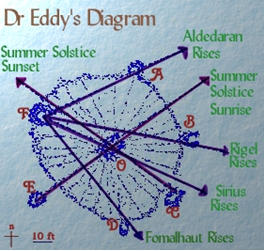
Fig. 2 |
Sighting from cairn E through the center hub (which
may have supported a pole) marks the summer solstice sunrise. Sighting from C through the center marked
the equivalent solstice sunset. Standing at
cairn F, one could sight the once-yearly dawn, or heliacal, risings of the
key stars Aldebaran, Rigel, and Sirius, which
play symbolic roles in an ancient |
The
dawn or heliacal rising of a star is important because it pinpoints a date
exactly. This is the
day a star is first seen, just before dawn, after it has been behind the Sun for an entire season. From about 1200 AD to 1700 AD, these 4
stars would have acted as solstice markers for the Native Americans -
Fomalhaut (F to D) would rise 28 days before the Summer Solstice, Aldebaran (F
to A) would rise during the 2 days just before the solstice, Rigel (F to B)
would rise 28 days after the solstice, and Sirius (F to C) 28 days after that,
at the end of August
Now although there are many other things I could point out in this article, I will only address the bold text points with a little deviation. I don’t know who wrote this article but it is typical of the things that seem to be among the accepted explanations.
We read about the alignments of Aldebaran in Taurus, Rigel in
Orion, and Sirius, and my first question is, who cares? For us to
believe that these alignments were somehow significant to pinpointing some date
with constellations is ridiculous. What? You can’t do that with the alignment
of the sun? Does the Sun rise in a new location every day? Would this be like
trying to find the forest but can’t see it for all the trees? Why would the
ancients ignore the sun’s rising positions and choose a FIRST APPEARANCE of a
star instead. You don’t need some big wheel made out of stone to SEE
its FIRST
APEARENCE. Isn’t a FIRST APPEARENCE sufficient to pin
point that day in which it FIRST APEARED? And do we need to
hike to the altitude of 9600 feet to SEE its FIRST APPEARENCE? Is any
one catching what I’m saying? Are we insinuating that the ancients were idiots?
Isn’t it obvious as to who the idiots are? Let me say at this time, I do not
believe that the Indians as we know them today are the ones who have
constructed this wheel, and that this comment is not for the purpose of
diminishing this noble people. With the exception of a few tribes such as the
Lenape and Ojibwa, the various tribes had no writing system and chose to resort
to oral
tradition. Since none of them claim to have made the marks upon the
rocks or to have been responsible for the Earthworks of the
In this same article it is said that these stars which
play symbolic roles in an ancient
In the article, it is written: From about 1200 AD to 1700 AD, these 4 stars would have acted as solstice markers for the Native Americans. Why? Was the Sun missing in those days? But the one statement that got me more than anything else was the concluding statement, and hence marking the end of summer and time to leave the mountain. This is the most asinine statement yet. I don’t suppose the increasing cold weather and the turning of the leaves or even the early snow might have been a clue as to when to leave the mountain? What? They sat up there day after day waiting for this prophetic sign? Who was tending the sheep down below?
A friend has mentioned that this could simply be a game of duck duck goose, and is it any less ridiculous than the theory for the alignments with stars?
What is it?
In order for anything pertaining to this geo-glyph and/or observatory to make sense, we need to understand some things pertaining to the ancients of which the Indians are in part the descendants of. What was it that they worshipped, Stars? Many of the tribes in the origin and creation legends make note of a supreme being and many of those acknowledge the Son of God (including the Aztecs). Many of the tribes, though they communicated in many ways, made it clear that they worshipped the Sun, or more definitively, that which was behind it. Being clarified, they meant the power behind it. The only logical explanation in which this circle of stones was built in such a high place is not for a game of alpine duck duck goose but because of the vantage point of being able to see the largest spectrum of the horizon.
In the Native American Petroglyphs, the symbol for sky
or the horizon around it is the circle with a base meaning of Holding,
in other words it is my belief that the circle itself represents the
horizon as viewed from this ideal location. (See the Article; Aztec
Navigation Glyphs) Each of the
The purpose of marking some point in time would be best understood by us in our celebration of the Birth of Christ on the specific day of December 25th (which of course is not the correct day). We also have specific means by recording and observing the shortest day, the longest day and the two times each year which mark a time when the day is equal in time with the night or the mid point between summer and winter. We don’t need stars for this but there are many reasons why anyone (including the ancients) wanted to know these times specifically.
Also, take into consideration that regardless of the mountains around a valley, the same thing could have been accomplished in a valley, why did they choose to construct this wheel at the highest point? Many times throughout scriptural history we read of Prophets going to the tops of mountains to speak with God. Even today, many feel more connected when praying in the mountains. The point is that it would seem quite clear: the reasons for its construction are religious in nature as I can find no other reasonable explanation which warrants its construction at one of highest points around.
There are two things that need to be determined. (1)
When was this built? I don’t think it is possible to find out exactly when it
was built but perhaps it is possible to discover if it had Origins in BC times.
(2) We have the need to discover if it truly has any Solstice/Equinox
alignments or related perspectives as well as comparing AD times with BC Times.

Fig. 3
In looking at Eddy’s drawing of the wheel above, we
see the alignments that he noticed. It would seem that he noticed two solar
alignments, of which, both appear to be noteworthy.

Fig. 4
It has been said that Eddy’s alignments would have been more accurate for 1200 to 1700 AD. I would love to hear what this excuse for non accuracy is based upon; let’s see how accurate it is in the above image (Fig. 4). The red lines are based upon full sun above the horizon at 5.3 degrees elevation which is the first point of Full Sun. At Eddy’s sunrise position, I must admit that the sun peeks over and casts its first light at his projected point with half sun exposed in between his projection and the red line. This is with a visual horizon at 100 feet higher at 4.3 miles away. What this means is that Eddy’s proposal of alignment is acceptable for the Summer Solstice sunrise. The red line at the sunset position is basically the same in reverse; for sunset at the red line we have full sun at 5.3 degrees elevation with a visible horizon at 1600 feet lower at over 30 miles away. If this is the case and not much adjustment is needed, this would place his sunset position nearly correct at full sun. I find, at two other points, satisfactory alignments with Winter Sunrise and Sunset, but not as acceptable as the summer positions, however, who is going to be up there in 4 to 6 feet of snow to see it? I cannot find any other solar alignment within this stone circle based on today’s North.
What if this were constructed in BC times? What solar
alignments would we find?
According to my compiled research, I have established a BC North Pole and with this pole in mind let’s see what we can come up with.
In the following image, Fig. 5 using Eddy’s cairn letters, you can see a red line extending from Eddy’s C Cairn to F which would represent BC north (F) and south (C), Notice the line does not intersect with the center. I would almost think this was intentional as if to say, it was not meant to align with the horizon. In similar stone geo-glyphs with solar alignments, I have noticed that there is a North reference. I would suspect that if the outer circle correlates with the meaning of horizon then is it possible that the center cairn represents the Sun being held and that the outer dots are showing different locations on the horizon?
The Yellow line extending from D through
the middle points to the BC Summer Solstice Sunrise. This position is
calculated at 47 degrees azimuth and 4 degrees elevation of the sun (5.3
degrees being FULL

Fig. 5
At the sun’s position with the line at cairn B
extending through the center based on 324 degrees azimuth at a 0 degree
elevation, if the visible horizon were not 70 miles away and 1000 feet lower we
would have a ½ sunrise, but it is 1000 feet lower and 70 miles away, so this
means that at approximately 324 degrees azimuth we have full
sun, another perfect alignment. Keep in mind that at 60 degrees Latitude, the
sun moves laterally more than it does vertically. 60 degrees was the latitude
in BC times, today it is located at a Latitude of 44.83 N.
What about an equinox sunset or sunrise for that
matter? In Fig. 6, from the position of cairn A, a line extending though the
center in BC times would be about 260 degrees. The visible horizon is some 150
miles away and 3000 feet higher. Not taking this into consideration and based
on an equal elevation; full sun (at a 5.3 degree elevation) would be at 162
degrees. However, considering the horizon is 3000 feet higher and 150 miles
away, if an additional 1 degree was added in elevation (which seems
reasonable), full sun prior to sunset based on this information would be at 260
degrees azimuth, which is a perfect alignment for the equinox sunset. However,
this is one that I would have to see for myself.

Fig. 6
The equinox sunrise, in order to fit into the same
alignment opposite of the line in the previous picture would require 79
degrees, but the sun at this point would have just have peeked over the visible
horizon which is a little over 7 miles away and 300 feet lower. Although this
could prove to be an accurate alignment, I’m just not satisfied with it.
At full sun, the alignment would look something like
this.

Fig. 7
I would think that the equinox sunrise would be
considered an important alignment and one that the ancients would be most
concerned with, however I must say that although it is good enough, I was
slightly disappointed. I guess I’ll just have to go see for myself that is
unless there is another possibility. How about this…? SEE Fig. 8

Fig. 8
The only thing that puzzles me about this is, why not
set up a cairn in such a way that if a line were drawn on it, it would pass
through the center? I don’t know why this is important to me, it just is.
Perhaps I am being too meticulous. Now the fall and the spring equinox sunrises
occur at 98 degrees azimuth, both alignments in
the above picture are at 98 degrees. Is this just a coincidence?
If so, it’s a pretty good one.
Winter Solstice
Now although I really don’t think anyone would be
there to witness it, and can’t think for the life of me why anyone would
indicate a winter solstice sunrise at such an elevation, it would appear that
it is present, See Fig 9. Considering that the visible horizon is about 300
feet lower and a quarter mile short of 7 miles away at 141 degrees, if a line
were drawn from the center cairn through cairn B (Opposite Summer Sunset); this
would mark the exact placement of 141 degrees azimuth at near full sun.
Strangely enough, if we allowed the sun to continue to
a full sunrise, we would be at approximately 159 degrees. Keep in mind that the
sun at this point during the winter is traversing the sky in more of a
horizontal path than a vertical one. If a line were drawn from Eddy’s cairn D
to cairn E and beyond this also would point directly at full winter solstice
sunrise.

Fig. 9
With the winter solstice sunset, we have remarkably
the opposite. A line drawn from the center through D which is at 224 degrees
azimuth is exactly the opposite of the summer solstice sunrise with the visible
horizon only a mile away at the same elevation. At 224 degrees the sun has gone
down with only about 1/4 of it exposed. If we come back to full sun prior to
solstice sunset, the sun is at 195 degrees azimuth. With careful positioning of
our lines, we can get two alignments that meet at a measurement of 195 degrees.
What I mean by careful is for you to notice where the line leaves cairn F and
passes through D and where it leaves cairn A and passes through B, it is not
perfect. Maybe I’m just being too meticulous again.

Fig. 10
Fig. 11
What about other alignments? In looking at cairn E naturally I wanted to see if this aligns with something significant. Why is it removed from the outer circle as if to imply that it has some other meaning?
In Fig. 12, If a line were drawn from the center of the medicine wheel to cairn E it marks a place on the horizon some 77 miles away and 100 feet higher than that of the wheel. The dates we have a sunset with full sun at this location in BC times would have been the Evening of May 11th and the evening of July 30th which is at 297 degrees azimuth. What is interesting about this is that from the sunset of the 11th of May to the Summer Solstice sunset is 40 days, the 11th of May and the 21st of June (not inclusive). The return trip of the sun from the 21st to the 30th of July (inclusive) is also 40 days. This same thing appears in other suspect Adena mound sites, why would these suspect Hebrews be observing a 40 day period let alone two consecutive? Why this 40 day observation period?
It would appear to be an 80 day
period of two 40 day observation periods. What could have been the purpose of
this 80 day observation? In the scriptures we observe the 40 day fast of Moses
to receive the higher law then after receiving it, Moses returned to the
Israelites whereby he had seen their iniquities and broke the tablets. Then he
returned to the mount and fasted another 40 days to receive the lesser law.
Interestingly enough, the Aztecs had a similar fasting ritual. The point is
that according to today’s North, it would not have any meaning whatsoever and
the scientists would be just as confused as they seem to be concerning the Murray
Farm Tunnel.

Fig. 12
What about the sunrise direction? Is it also
present there? Well guess what. Yes, it is and without a stretch of the
imagination or the facts, a line drawn from cairn D through the center is Summer
Solstice Sunrise. In Fig. 13 a line drawn from cairn D through
cairn A will give us a 62 degree azimuth for the Mornings of May
11th and July 30th. It is a repeat
of the previous two forty day periods except that it is for sunrise instead of
sunset.

Fig. 13
But wait a minute, haven’t we heard this before? It would seem that the same dates are two consecutive 40 day periods, which are also present at the Milford Earthworks.
The Plains Indians didn’t build the Milford Earthworks. Some people called the Allegwi did. You know, those people who were run off and went south and became the Aztecs?
Yes, the Aztecs who in part came from the North who also have two consecutive 40 day periods of Fasting, like Moses when he received the first tablets for the Israelites and after breaking them had to return to the mountain and fast another 40 days? Where did the Allegwi learn this? Oh well, no matter. I’m sure it is all a coincidence.
All of the above information is exact and true to the
best of my knowledge without any stretching of the truth or the imagination.
Visual horizons were considered in each case and determined accordingly. Anyone
who would like to see the full details of how I arrived at each location is
more than welcome and I will be happy to explain it further. But the best way
to verify all of this is to go to the site and set up wooden stakes at the
adjusted locations according to BC North, we could implement a pole change back
to where it was, but history shows this can be catastrophic and besides, it
won’t be long before it will be happening again. I hope you are all prepared.
The Geo-glyph
Many will not understand what is said in the following but it will reach those for whom it is intended, even so, I will do the best I can to make it clear. There is much speculation as to what a medicine wheel is and what it was used for. Aside from you creating a medicine wheel for your purposes, I have yet to see anyone identify what they were used for, the idea or concept in some cases is similar, but not even the Indians who use them today seem to understand what they were. This is because the knowledge of the symbol based glyph system is nearly extinct.
These circles of stones were created by the same
people who pecked the glyphs on the rocks found everywhere in

Fig. 14
If you view this as a glyph and recognize the various symbols that make it up along with the positioning of the symbols, it will identify its purpose. The symbols that you see within this wheel use the base meaning of Holding, Place of Dead, and Holding in one place. The individual would sit in the center with the idea of being surrounded by his ancestors who have passed on, by the ancestors surrounding them no evil could come to them and their purpose for coming to the medicine wheel is thereby uninhibited by evil spirits.
In Fig. 15 the medicine wheel was used specifically
for communicating with the creator, God above, the Son of God, or the Sun of
God. I
am the light and the life of the world.
This is said 11 times in our scriptures and yet we
suppose that the Ancients didn’t understand this? Most of us don’t understand
it, but the Ancients did. It will ALWAYS be located where it catches First
Sunlight. If it isn’t, then it was built by someone other than the
Ancients; such as the new-agers, or a later people who have forgotten its
purpose or never knew it.

Fig. 15
Simple, direct and to the point.
There are many other uses of medicine wheels and each
identifies its purpose by its construction. With the knowledge of the symbol
based glyph system of hieroglyphs, we can identify its purpose. Fig. 16 is just
another of the many that exist.
Fig. 16
The Big Horn Medicine Wheel had a similar purpose to
that of Fig. 15 and 16; however, it has many interesting things integrated into
it. In addition to the alignments which seem to correspond with different
aspects of the Sun, hidden within the wheel is still more that clarifies its
purpose. If one is to connect the dots so to speak it reveals the following in
Fig. 17.

Fig. 17
With a little understanding of the glyphs, the circle itself (as pointed out earlier) represents the Horizon as being the border of the sky. The center Cairn represents the Sun, Son, or creator who oversees all that is under the sky and in the sky. Each Cairn positioned at the many places around the circle represents a specific location on the horizon or a point in time which was significant and important to the Ancients as it relates to that which they believed.
When we join the perimeter
Turning to the pages of…
“We will now draw these symbols
that you may better understand them:

“You will notice that there are two triangles, one with the point downward, and the other with the point upward. These are combined in the symbol of the interlaced triangles, or the six pointed star. The triangles when used separately gives each triangle a distinct and separate meaning. The one with the point upward, is called the symbol of manifestation on the, material plane, and symbolizes mankind focusing their thoughts on God; the triangle with the point downward represents manifestation on the spiritual, or Divine plane, and symbolizes God’s consciousness focalized on mankind. In this six pointed star formed by the interlaced triangle we symbolize the blending, or uniting, of the physical and the spiritual.
The square represents building uprightly on a strong
secure foundation. The circle, which is endless, is the universal symbol of
eternal life. The square and the interlaced triangles are the only two
equiangular and equilateral figure, the sum of whose exterior angles equals 360
degrees, or perfection, as symbolized by the circle. From these symbols, we
learn that by building uprightly on a strong secure foundation, we unite the
physical and the spiritual, and with them inseparably connected, as symbolized
by the interlaced triangles, we have eternal life.”
What better symbol to manifest itself over all of the medicine wheel than with the very thing that it represents positioned in the center and with its purpose and concept clarified in the symbol itself? This is a place where the Ancients went to communicate with their God and to observe certain points in time having to do with him or some observed event of the past. Some are known to us along with their significance, and some, I am quite certain, that we have forgotten. They didn’t NEED the medicine wheel to tell them these points in time; they used it for the purpose of the observation of principles that were important to them so that they were observed at the right point in time.
Were they any different than us? Do we not now begin to observe the day of Christmas the very day after Thanksgiving? 25 days before the intended day! How ridiculous? Do we not go through many rituals leading up to this day? Do we make several trips to the merchants for the purposes of hanging strange illuminated objects from our houses and for placing them in our yards? Do we make visits to the Mall to put our children in Satan’s Claws, or attend Christmas parties (ceremonies) worshiping some short fat man in a red suit and a mythical deer that flies? Do we not make sure that every little detail is perfect in respect to this according to our own individual beliefs? Rest assured IT IS going to happen the morning of the 25th! These people MUST be Pagans!
We can’t seem to understand that the Ancients were not so different as you or me. From what I can see of them, it would seem that they at least understood whose birthday it was, and what day it really was and who they worshiped. I hope that this article will help you to understand that things are not always as they seem, in fact they never are. What are all the lines that radiate from the center Cairn? They are not uniform, were they put there to make it look more appealing? Is it possible that they are a representation of some points in time? Why are there 28 of them, why not 30? Why is one Cairn set apart away from the main circle seemingly unattached? Why are there 6 of them? Is there more to this wheel than we know? I am certain that there is much more to this wheel and I am sure much more concerning it will come out. For now this is all that I choose to say about it.
In conclusion, The Ancients built this medicine wheel, if that’s what you choose to call it, for the purpose of Worshiping One God, and they knew who He was. They knew the specific points in time for worship according to the event to be observed, which is much more than I can say for this people today.
If science would at least consider a creator, intelligent design, and theories they so quickly dusted under the rug for fear of peer pressure they just might come to understand many things…
Things such as the mystery of the sunken cities of the
Mediterranean, where did the ocean disappear to that once covered

No comments:
Post a Comment
Thank you for your comment!