
Will the true history of this continent ever be told? A history that has never been told, at least not in a way that connects the many fragments of discoveries, legends, scriptural references, histories of cultures not considered, and many other sources. Some day I may attempt to undergo this task, and even then only a small part will have been told. Who is it that writes the history? Or should I say, what is being passed off as history…
Today my focus is on a particular potential discovery, and I am going to say it now, I could be wrong, but if I thought I was possibly wrong, I would not be writing this, and even if I am wrong about the final conclusion, the evidences of the overall chain of events that occurred along the way, is so profound, strong, and compelling, I don’t know how it can be ignored, but it will be by many… and the reason is, they simply and literally do not care.
I must also tell the reader, that my critics will most certainly rear their egos, maybe more than usual, because not only will this Hypothesis reach them, and their unbridled pride lash out, but I will also have to contend with a group of people whom this hypothesis would most benefit if true, if they can see what I believe to be the truth, and it is found to be true.
However, my faith in man is weak these days. The very people whom I am trying to share this with, whom it would be most beneficial to if true, will be my worst critics… why? I refuse to elaborate further…
Of the many untold histories and discoveries already made, but not made public… there is one, which I believe will some day, come to be known, if it is sooner or later, is not for me to say, if true, it will be when it is expedient for the public to know… for now, just sit back and enjoy the story, which you at this time have no choice but to class it with a historical fiction, which just might someday become truth.
My apologies for any redundancies found in this segment, but I feel it necessary to connect the dots, so to speak, as it is all connected… something I just cannot escape…
I also apologize at this time for what seems to be in the past, an effort to write tight lipped, I confirm at this time that it is true, and I can only say that in this article you may find the same, but I will try to loosen up a bit where I can. I wish I could explain the many reasons why I often feel constrained to what is said… I could offer a few… shall we say excuses? at this time, but let this one suffice... there are just some things, the general public ought not know.
Those of you who have followed my research in part, or from the beginning, may be familiar with the contents of the Book Nephite North, and many articles buried in the archives of tuscoro.com or even the expanded versions found in the 3 volume set, The Forbidden Histories of the Americas (Articles from Tuscoro.com)
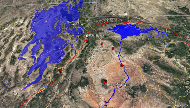
Sanpete Valley
Today I am going to direct your attention to a place here in Utah, called the Sanpete valley, located in central Utah, a place where the inhabitants, and those connected to it, continue their lives, day in, and day out, never knowing or understanding the significance of this place, and the untold histories of events that have occurred here, or those that have been told, and they do not know that this place is the true setting.
According to some of the academics, the history of Sanpete started in the fall of 1849 when the settlers arrived… really? How boring. And if you are bold enough to visit WIKI, we have this;
"The Sanpete Valley may have been traversed or inhabited as long as 32,000 BP, by small bands of hunters. This probably continued for about 20,000 years, at which time the extinction of larger game animals forced a change. About 8,500 years ago, different groups (characterized by use of atlatls, millstones and textiles) came onto the scene. These also departed the area about 2,500 years ago, for unknown reasons, after which the area does not seem to have been visited by humans for 1,500 years.
Archeological evidence indicates that the Fremont people appeared next on the stage, the first inhabitants to domesticate crops and to create relatively large communal settlements. In this county the best-known Fremont site to date is "Witch's Knoll" three miles (5 km) SE of Ephraim. Around 1300 AD the evidence of Fremont habitation also ceases. The most recent groups of indigenous Americans in the Sanpete region are the Ute, Paiute, Goshute and Shoshoni, all sharing a common language family called Numic". [Uto-Aztecan]
I admit, I'm torn, I don’t know whether to be amazed, fall on the floor laughing, or throw up in my mouth… however in an effort to keep from sounding, or being smug, I’ll just put on my hip waders, and move on… I don’t dare read anything regarding the geologic history of Sanpete Valley…
The following may sound conjectural, but I assure you the evidences are many, which may, or may not be included in this article.
The First Inhabitants.
Approximately 4400 years ago, the first people arrived on this continent after a great and terrible global flood, they arrived and set foot, very near what is now called Las Vegas, Nevada. When they arrived, the land there, and Northerly was nothing as it is today, it was semi tropical, and almost heavenly environment. Within the next few hundred years, people spread abundantly all over what is now called the west. Sanpete Valley in that day, lay in an Easterly direction, there is no doubt the valley was inhabited at this time.
Cities sprang up everywhere, including the area of the Sanpete Valley. Other cultures also came to this land, in those early days; however, it is unknown whether these other cultures were in the Sanpete area. One such culture came from India, prior to the days of King Solomon, one may read superficial evidence of this in the book 1st Kings… yes, in your Bible, or you may find additional, more profound evidences in the Book, Nephite North, and the Book, The Forbidden Histories of the Americas. What events took place over the next 1600 years is vague, but these people, as a result of their iniquities, brought an end to themselves as a people. Sometime near 650-600 BC there was a great battle between the two primary divisions of this people, this battle ended in the Sanpete Valley, with millions of people strewn over the ground with literally no one left to bury them. It is no wonder why this area became uninhabited, or why they “departed the area” for “unknown reasons” approximately 2500 years ago.
One such evidence that shows this event likely happened, but not necessarily when, can be found in the book Nephite North, in the chapter “Ye are Salt of the Earth” Another clue might be to wonder about the lowest point in the valley, the Redman Salt Mines, do you really think that these salt deposits just magically show up where mother Nature decides? What if we were to follow the water runoff path, to the end of the river that travels through Sanpete, and
ends at Sevier Lake, which is known for what? Again here is that salt, you must admit you are now beginning to consider the destruction of Sodom and Gomorrah, and that strange sea we take for granted, called the DEAD Sea. How about the destruction of Jerusalem, also found just upstream from this curious sea of Salt where Lot’s family was told to flee, and not to look back, but what did Lot’s wife do? And what happened to her? Better yet, what happened to the inhabitants of Jerusalem? Why Salt? If you don’t know, then maybe you don’t need to know, or you can find out by reading the chapter “Ye are Salt of the Earth.”
It is unknown as to how long that salt lay upon the ground in Sanpete Valley, or whether it was swept clean in those days, a later account makes it quite clear it was swept clean. I often wonder where Salt Creek got its name. The presumed academic WIKI report says; following, the inhabitants “departed the area,” and does not seem to have been visited by humans for 1,500 years.
About 5-600 BC another culture came to this area, those who carried the Haplogroup X dna, or, were of Hebrew descent, how long it took them to inhabit the valley is unknown. By 100 BC another Culture or two entered the scene… One from China, but, according to their records, they did not stay long, and the other we would refer to as Indo-Greeks, some of you might know them as Gadianton. Which of the two inhabited the Valley of Sanpete is unknown at this time, perhaps both, but they also built cities, or at least re-built cities of the previous culture. At this time, the land was still a semi tropical environment, and likely looked very different than it does today, all this would change in about 900 AD.
What these two cultures did, and how they interacted is unknown, and would most certainly be conjectural should I elaborate, however, in about 385 AD another great battle took place, in the same area as the former battle, and the results were the same. I often wonder, how many have come to the realization that this event was the final straw of what we have heard in certain histories as, “the fall of the Western Roman Empire.”
It’s not a stretch… Millions of people, again, lay strewn upon the ground with no one to bury them, and once again, due to the stench, and the stigma, the area was uninhabited again, and likely remained as such for at least a few hundred years. However, someone after this, built, or rebuilt a city, perhaps even two, it’s possible the structures are much older, but due to implicating evidences, it would be my guess they or it, was built after 500 AD, but before
900 AD. Prior to the Event of 900 AD, this place was mostly a land of many waters, rivers, and fountains.
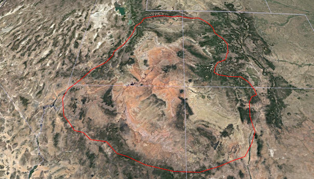
Boundary of the Colorado Plateau Uplift
The Colorado Plateau Uplift
In about 900 AD, if not the very year of, something incredible happened here in the west, which mostly affected Utah, the Colorado Plateau uplift. It also had its affect in Nevada, Idaho, Colorado, Wyoming, New Mexico, Arizona, and even as far as California. This event is specifically why the Aztec left their homeland Aztlan, although the Aztec record does not specifically address this. All that gives us a clue in the record, is that it says they left in humility. Why don’t we know about this event? Well… some of us do, but it has been masked over by the academic time machine, and in this case it is said that the event happened, or began as far back as 600 million years ago, and happened over millions of years, when in fact it happened likely in a day, and only 1100 years ago. Now I have never wrote about the Colorado Plateau uplift in any detail, however, in an effort to not rehash, you may re-read, or read a previous article found here… Undiscovered Histories of Utah.
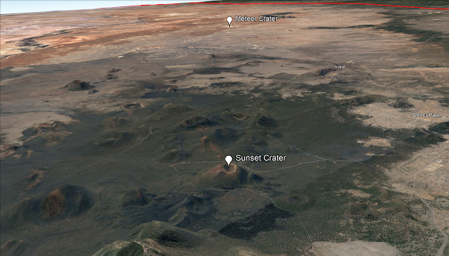
Barringer Meteor Crater
We may never know exactly what it was that initiated the events of the uplift, but it had its affect at several geologic areas, creating events all the way around the borders of the plateau. However there is one geologic event or should we call it an astronomical event which occurred about 20 miles or so if not on the border of the south end of the boundary of the Colorado Plateau uplift, just a little to coincidental for me. For years I never gave it much consideration simply because I underestimated the magnitude of the impact, it wasn't until I noticed all the seismic activity in the way of Volcanic activity in and around the immediate area, this would be the Barringer Meteor impact Crater in Arizona. Could this have been what triggered the Plateau event? The Academics claim it occurred about 50,000 years ago but as much credence as some would give those who toss these dates around like they actually know, is staggering to me. My hypothesis would be that at about 900 AD a comet was observed by the ancestors of the Aztec and the strike carried just enough energy to set in motion the already fractured area as a result of two previous and violent pole shifts of the past. This in and of itself would have almost been enough to cause the Aztec to wonder if they were right with their God. After all the events surounding this cataclysmic event, and with the climate changing from semi Tropical to high country desert, I can see why the Aztec say they left their homeland in Humility.

Barringer Meteor Crater claimed to have struck earth some 50,000 years ago with absolutely no evidence to substantiate that guess...
Just to the North West of this meteor impact, is one of the larger Volcanic mass areas here in the west, Sunset Crater National Park contains quite an array of volcanoes including the more famous one at the site, Sunset Crater. Strangely enough, the academic event dating system must have been shut down, because their guess of the time frame of this even is placed at approximately 950 years ago, derived from tree ring dates of all things... now there's an idea... Oh well, they are getting closer. Incidentally, someone please remind me to write concerning the true nature and origin of Volcanoes... Did you really think our planet has a huge ball of 9,329 degree molten lava nickel in the center that to date being "billions" of years latter is STILL "cooling off" all the while carrying two Ice age glacier packs several miles thick and at the same time trying to convince us of global warming? If this were true, all life on the surface would have been cooked beyond cinders billions of years ago... when will the people stop buying into the bullshit?
According to the Paiute, fire spit from the ground in the Cedar City, Parowan area, the waters in and around Cedar City, and Parowan, suddenly rushed northward, this should be a clue that lake Bonneville still existed, and was not created 14,000 years ago at the end of some fictitious last ice age. Lake Bonneville was created as a result of the cataclysmic event that occurred at the time of the crucifixion, this later event cause the first stage of Lake Bonneville’s disappearance, which caused it to lower from its highest level of about 5200 feet down to 4800. It also set the stage for the waters that fed Lake Bonneville for near 900 years, to slowly return underground which led to its eventual disappearance. When the plateau tilted on the west side, it caused lake Bonneville to shift, sending a wave of water northward, which is the force that slammed into and burst thru Red Rock pass in Idaho. A tilting or rise in the Uinta Mountains, due to water pressure, sent lake Coppola (Uinta) rushing southward breaking through its natural barrier, which carved out another thousand feet of the Grand Canyon floor. There was an up rise in the Northern Colorado Mountains, also, (this likely occurred prior to at the events of the crucifixion) this obliterated a Natural river, which flowed from Lake Coppola easterly and was the upper most and main feed of the Missouri River, since creation. In ancient times it was likely the river Pison, and in later BC times it was known as the river Sidon. If you look at the topography, at the juncture of the Missouri and Mississippi Rivers, it is clear where the main flow of the lower Mississippi came from, in the days prior.
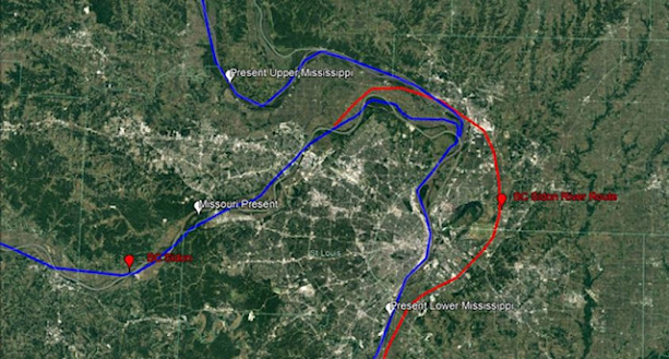
Missouri and Mississippi Confluence
In Utah, west of Fillmore, also Parowan, and the Saint George area, and around Mount Trumbull, all spewed lava from the fractures created some 900 years earlier, but more likely from 3600 years earlier, in the days of Peleg, “when the Earth divided” and this does NOT mean Tectonic Plates, or Continental shift, both theories of which are pure rubbish.
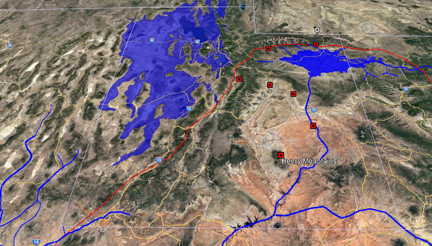
The Colorado Plateau uplift was a cataclysmic event, and was recorded, not only by the Aztec and Paiute, but the Roman Colonies, who were here at the time. Now as it pertains to the main topic, we have not yet come to, along the northwestern border, of the Colorado Plateau uplift, is Sanpete Valley… The tops of the mountains, above the valley, towards the east, opened, and the rivers flooding the valley washed everything on the surface down, and it now rests at Lake Sevier. If you doubt this part, for whatever reason consider this…
Waters of Ripliancum
Isaiah 41:18
18 I will open rivers in high places, and fountains in the midst of the valleys: I will make the wilderness a pool of water, and the dry land springs of water.
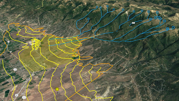
And for the visual critics, take a close look at the geologic make up of the mountains east of Sanpete county, from Ephraim to about Indianola, and especially the formation that the local inhabitants know very well, Horse Shoe Mountain… this horseshoe formation was NOT created by some fictitious Ice Age, nor was it made from glaciers which have never existed in these mountains. These formations were created as a result of high pressure, waters from an underground source, waters that literally exceeds all, and breaching the tops of the mountains, flowed down. Some refer to these waters as the waters of Ripliancum, no wait… my mistake, they don’t…. Also look at the east side of the Manti La Sal Mountain Range, formations which are abundant and sent the waters down on the east, through Castledale, and Ferron Utah.
Where does all this water come from?

East of Mount Pleasant looking west
Look at the geographic makeup of the valley floor in the suspect area, you will find 6 very large alluvial fans, comprised with the well known boulders of Fairview, Mount Pleasant, Spring City, and the drumlins as a result, reaching as far as Ephraim. Just one of these alluvial fan boulder fields takes in no less that 3600 square acres, or approximately 6 square miles. The locals contend with them every time they dig, the landscape companies in Salt Lake harvest the boulders for landscaping, yet no one ever asks…. These boulders are sized ranging from not much bigger than a football to the size of a Volkswagen Bug. Where did all these boulders come from? Well, if you were standing at Spring City, or south of it, asking that question, I would say while pointing to the east… look at that big missing piece of Horse Shoe Mountain, for which it gets its name.
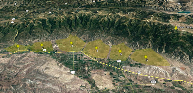
Six Alluvial Fans
Looking East over Fairview, Mount Pleasant, and Spring City.
When will the people as a whole realize, that, for over 150 years we have been fed nothing but theory and told it was fact? Where are the real thinkers and problem solvers? They are certainly not coming out of the Universities.
The following is a simple sketch, showing a cross section of Sanpete Valley, between Mount Pleasant and Fairview, from west to east, looking north, and although not perfect by any means, it shows what the valley may have looked like prior to the flooding event in 900 AD. The lower half shows the alluvial fan of boulders.

View would be from south, looking towards Fairview, from Mount Pleasant.
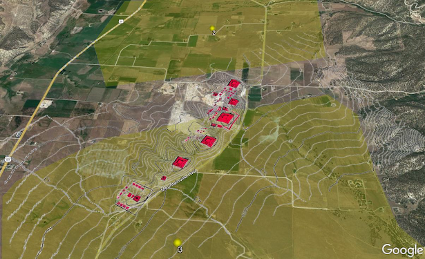
However, at this location between the two towns, there are some strange looking hills that geologist will say are drumlins, created by glacial melt. As many times as I have seen and read about the creation of drumlins by glaciers, I have never see one presentation, that did not include flood waters flowing under the ice, so why do we have to have a big thick layer of ice in order to create drumlins?

Mild Geologic uplift?
Could this be the source of the immovable object, which allowed the drumlins to form?
When I first saw these hills, I could see that something just wasn’t right, I imagined their creation, knowing that in order for drumlins to form, there must be an immovable object, in order for them to begin building. If the immovable object was a small geo uplift, perhaps created as a result of the overall Colorado uplift, why wasn’t it continuous? How could this uplift have 5 peaks? Although I am sure it is possible, it just didn’t seem right.

Or could this be the source of the immovable object?
Is it possible?
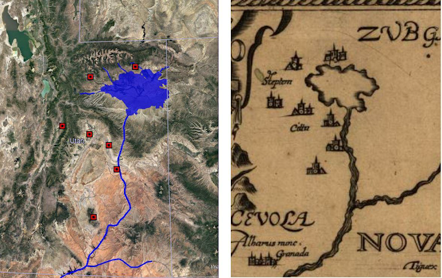
Hints of this valley’s past also pried at me… 5 peaks just seemed to obvious, so I decided to compare it with the only other “immovable object” I could think of, that might have been there on the valley floor, prior to this cataclysmic event… a man made structure. Thinking of the suspect time frame, I decided to check alignments, as the placement of the peaks seemed specific and not natural, I couldn’t help but think of the Sun Pyramid complex at Teotihuacán which seem to have the same alignment.
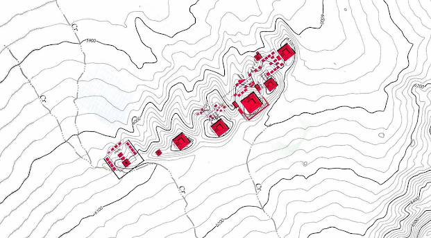
I said it once, and I will say it again, I could be wrong, but I highly suspect that when this cataclysmic event occurred, which is NOT in question, that the immovable object[s] needed to form the existing combination of drumlins, (Also not in question) might very well be some very stout man made structures, rather than an uplift with 5 peaks. Is it possible that one of the 7 Cities of Cibola has been found?

No comments:
Post a Comment
Thank you for your comment!